Select Stations to Find Your Route
Chennai Metro Green Line
Total Stations
15 Active / 0 Inactive
Line Length
22 km
Line Status
Active
Terminal Station
MGR Central (Chennai Central) St Thomas Mount
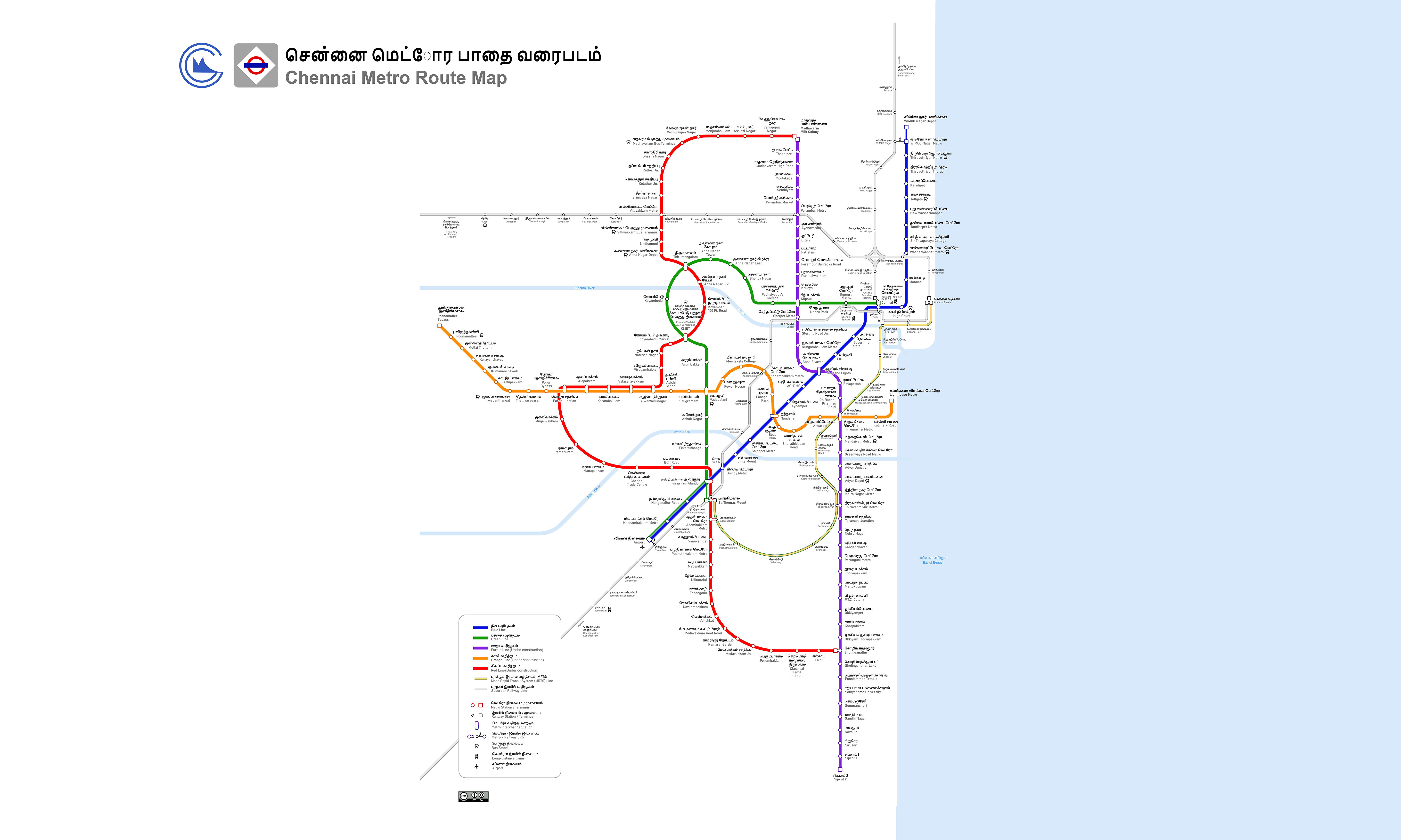
Chennai Metro Green Line Overview
Chennai Metro Green Line Station List (17 Active)
Status legend: Parking Feeder Bus Bank ATM Sulabh/Restroom
| Active Metro Station | Station Amenities |
|---|---|
| MGR Central (Chennai Central) Interchange | . . . |
| Egmore | . . . |
| Nehru Park | . . . |
| Kilpauk Medical College | . . . |
| Pachaiyappa College | . . . |
| Shenoy Nagar | . . . |
| Anna Nagar East | . . . |
| Anna Nagar Tower | . . . |
| Thirumangalam | . . . |
| Koyambedu | . . . |
| CMBT | . . . |
| Arumbakkam | . . . |
| Vadapalani | . . . |
| Ashok Nagar | . . . |
| Ekkattuthangal | . . . |
| Arignar Anna Alandur Interchange | . . . |
| St Thomas Mount | . . . |
No station under-construction or planned for construction.
Chennai Metro Green Line Map 2026
View the updated Green Line map of Chennai Metro, featuring active stations, under-construction stations, interchanges, and the metro Green line route.
Chennai Metro Fare Chart
Chennai Metro Green Line History, Facts and Expansion Plan
Get insights about the history, facts, and expansion plans of the Chennai Metro Green Line, including details about its development, infrastructure growth, and future improvements in connectivity.
- Chennai Metro Line 2, also known as the Green Line, is part of the Chennai Metro.
- This line connects the central, western and southern ends of the city.
- The line extends from Chennai Central to St. Thomas Mount and covers 17 stations of which 9 stations are underground and 8 stations are elevated.
- Chennai Metro Line 2 runs from Chennai Central to St. Thomas Mount, covering a distance of approximately 22 kilometres.
- Line 2 has interchange stations with other lines of the Chennai Metro, such as Chennai Central (Line 1) and Alandur (Line 1 and Line 3).
- Chennai Metro line is operational in 2 phases. The first phase from Little Mount to Chennai Central was inaugurated on 14 May 2017. The remaining section from Little Mount to St. Thomas Mount was opened on October 14, 2016.
Chennai Metro Green Line Phase 2 Extension
The Chennai Metro's Green Line is part of the second phase of the Chennai Metro Rail Project. The Green Line will be extended from St. Thomas Mount to Sholinganallur, adding approximately 47 kilometers and 47 stations to the network. It is planned to be completed by the end of 2026. In early 2024, Chennai Metro Rail Limited (CMRL) submitted a detailed feasibility report to extend the Green Line from Poonamallee to Parandur, which would add an additional 43.6 kilometers and 19 stations.
Chennai Metro Green Line FAQs
Find answers to common Green Line FAQs of Chennai Metro, covering stations, interchange points with other lines, timings, travel durations etc.
The Chennai Metro Green Line has several interchange stations from where passengers can transfer to other metro lines. These interchange stations are as follows:
- Alandur Metro - Interchange station between Blue Line and Green Line
- Chennai Central Metro - Interchange station between Green Line and Blue Line
Chennai Metro Green Line Timings
Chennai Metro Green Line runs on regular schedule throughout the week between MGR Central (Chennai Central) and St Thomas Mount.
Chennai Metro Green Line Timings from Monday to Saturday:
- First train: 05:02:00 AM (MGR Central (Chennai Central) to St Thomas Mount) | 05:01:00 AM (St Thomas Mount to MGR Central (Chennai Central))
- Last train: 23:00:00 PM
Chennai Metro Green Line Timings on Sunday:
- First train: 04:51:00 AM (MGR Central (Chennai Central) to St Thomas Mount) | 04:51:00 (St Thomas Mount to MGR Central (Chennai Central)
- Last train: 23:17:00 PM
Chennai Green Line Metro News & Updates
Get the news and updates for Green Line of Chennai Metro, including operational changes, expansion plans, station upgrades, and key announcements for commuters in Chennai.
Chennai Metro Rail has informed the Tamil Nadu government and the central government that the first section of the second phase, from Poonamallee to Vadapalani, can be inaugurated any time now. On Tuesday, Chennai Metro Rail received permission to operate trains on the 14.6-km route, with some relaxation in the speed and frequency of trains. Now, CMRL can run trains every 10 minutes on the Poonamallee-Vadapalani route.
A year on, Metro Rail yet to add and replace ticketing gates in phase I network, Commuters are often forced to take longer walks during peak hours as the ticketing gates are yet to be installed at all entrances in some stations; officials expect to finalise the tender within weeks.
Chennai Metro Rail Limited has announced that the Singara Chennai Card will be the sole travel card for Metro Rail services from May 1, 2026. In a statement, Chennai Metro Rail Limited said that the Singara Chennai Card, also known as the National Shared Mobility Card, was introduced on April 14, 2023, alongside the existing Metro travel cards. The complete transition to the new system is being done following the guidelines issued by the Central Government to ensure seamless travel on public transport systems in India. Passengers have been advised to transfer the balance available on their existing travel cards to the QR-based stored-value pass or Singara Chennai Card through the Chennai Metro Rail mobile application. Metro Rail officials stated that this change aims to enhance the convenience and integration of transport services, as well as to assure passengers of safe and reliable travel. They regretted any inconvenience caused during the transition period and appealed for public co
The inauguration of the Poonamallee to Vadapalani section of Chennai Metro Rail Limited (CMRL) Phase II is likely to be postponed until April. Although the CMRL received provisional authorization from the Commissioner of Metro Railway Safety (CMRS) to operate trains from Poonamallee to Porur (with some speed restrictions), the CMRS directed that train operations on the Porur-Vadapalani section be allowed only after the construction of 26 deck slabs in the double-decker Alapakkam-Alwarthirunagar section (in the Corridor 5 section).
Approximately 67% of construction work has been completed on the Chennai Metro Rail Phase II line between Koyambedu and Chennai Trade Centre. Officials have stated that this section is expected to open in June this year. This new section is part of the second phase of the Chennai Metro Rail project. Once operational, it will improve public transportation in the city and make travel easier for commuters.
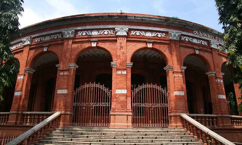
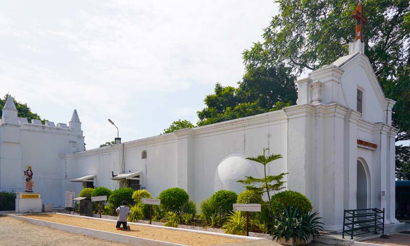
Top Attractions covered by Chennai Metro Green Line
Explore top tourist attractions, popular monuments, cultural sites, and landmarks near the Chennai Metro Green Line, that easily accessible via Chennai Green Line metro.


Saved Routes
Tap Save Route on any route page.