Find a BMRC Route
City Railway station to MG Road Metro Route
Fare & Timings

Station-by-Station Route
-
1
Start at City Railway station station. Entry Gates
-
2
Board the Purple Line towards Whitefield (Kadugodi) · from Platform 1
Ride 6 stops to MG Road. -
Arrive at MG Road station. You have reached your destination. Exit Gates
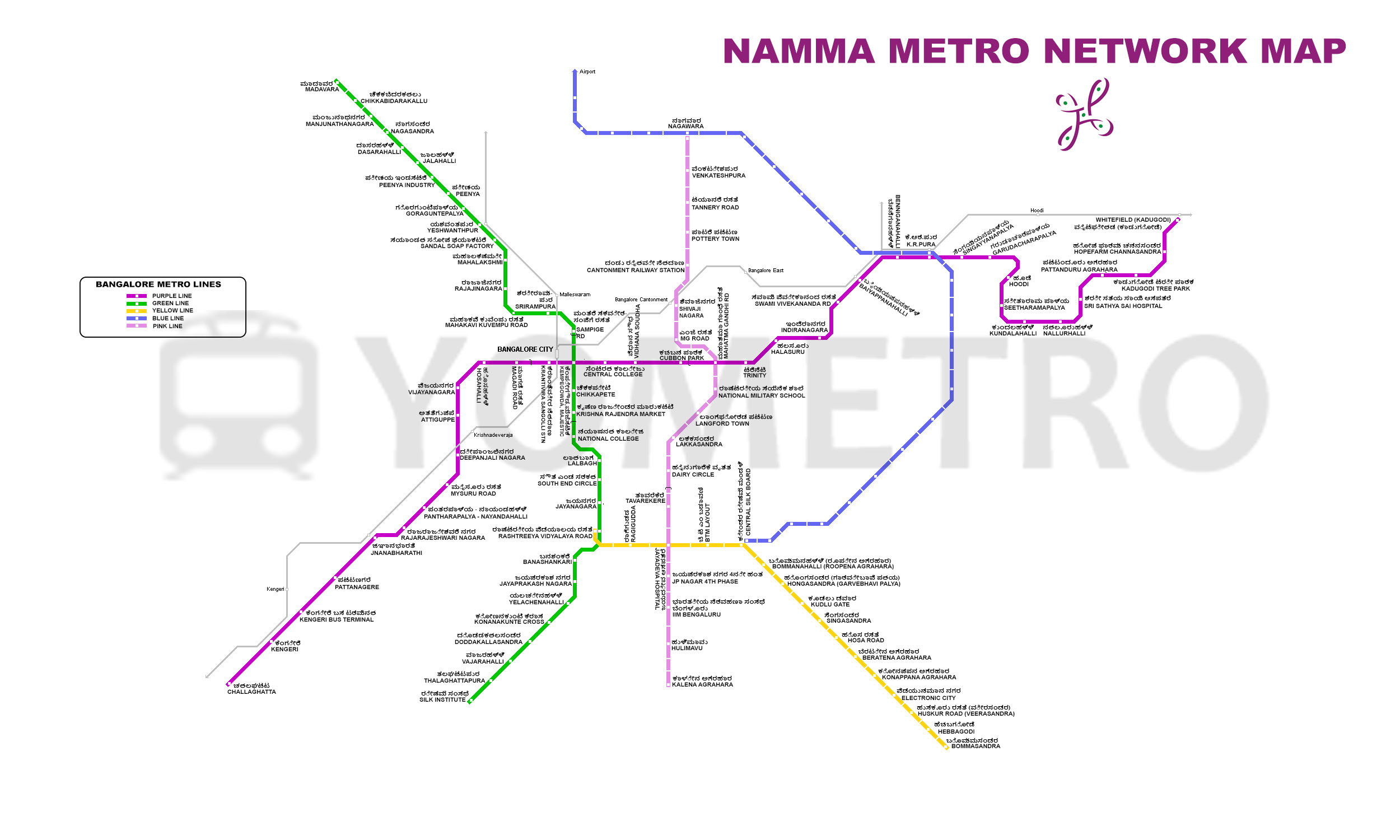
Bangalore Metro Route Map 2026
Route from City Railway station to MG Road on the map.
Route Summary
How to reach MG Road from City Railway station by metro? Board the metro from City Railway station station and travel through 4 intermediate metro stations. This is a direct route on the same line, with no train change required before reaching MG Road.
The approximate travel time between City Railway station and MG Road is 0 hrs 8 mins. The total distance covered on this metro route is 4.7 Km. The first metro from City Railway station departs at 05:26 AM, while the last train leaves at 11:31 PM.
The estimated metro fare for this route is ₹30. Smart card users may receive discounted fares. Parking facility is not available at either City Railway station or MG Road station.
Estimated Travel Cost Comparison and Savings based on distance & typical fares in Indian cities.
| Mode | Est. Cost | Savings vs Metro |
|---|---|---|
| 🚇 Metro | ₹30 | — |
| 🏍 Bike | ₹58 | ₹28 more |
| 🛺 Auto | ₹86 | ₹56 more |
| 🚕 Cab | ₹134 | ₹104 more |
Pre-calculated Weekly/Monthly Fare Chart
The fare shown below is calculated for daily, weekly, and monthly travel which includes both up and down journey and for a single person.
| Period | Cash | Smart Card |
|---|---|---|
| Daily | ₹60 | ₹57 |
| Weekly (5 days) | ₹300 | ₹285 |
| Weekly (6 days) | ₹360 | ₹342 |
| Weekly (7 days) | ₹420 | ₹399 |
| Monthly (20 days) | ₹1,200 | ₹1,140 |
| Monthly (24 days) | ₹1,440 | ₹1,368 |
| Monthly (28 days) | ₹1,680 | ₹1,596 |
Commuting with a Bangalore Metro Smart Card saves up to ₹84 per month on this route.
Metro Ride Benefits
- Carbon savings: 0.71 kg CO₂
- Fuel savings: 0.31 litres
- Time saved vs road: 6.0 minutes
- Calories burned (walk to/from station): ~70 kcal
Safety Tips
- Stand behind the yellow line while waiting for the train.
- Keep your belongings secure and within sight at all times.
- Let passengers exit before boarding.
- Hold handrails while the train is moving.
- In an emergency, use the help point or alert station staff.
